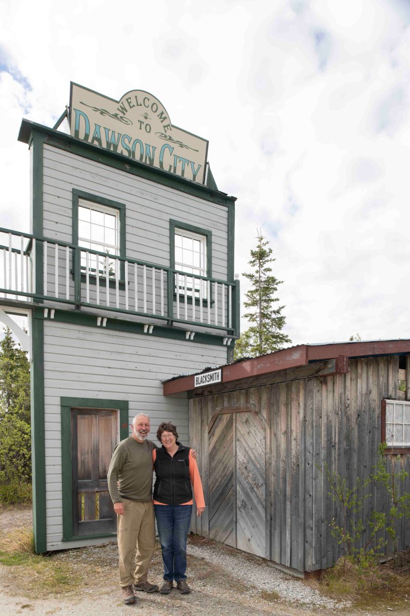
June 15

Chicken, Alaska to Slana, Alaska

Over night camping was noisy with the people that were ready to enjoy a weekend of music at the festival. A family with an RV arrived at one in the morning setting up right next to us. I was glad when we rolled out of Chicken. We were on the road for maybe 15 minutes when we spotted a moose with her calf. Later in the morning we spotted another moose with two calves. The road was paved but had frequent road damage spots and a few sections of gravel. On towards Tok. Tok was a spot for gas, laundry, and a few supplies. At Tok was turned south heading in the direction of Valdez. At Slana there is a 42 mile access road to the Wrangell Saint Elias National Park. We parked our trailer near the entrance to the park at a small and delightful RV campground then headed up the dead end road with the truck. The mountain views were simply jaw dropping. A few places creeks would flow across the road. I wanted them a bit higher to wash away some of the mud covering the truck but it was not to be. On the return to the campground Marsha shouted what was that? Apparently she had spotted a small mammal crossing the road quickly. I looked up and spotted a large canine crossing the road in hot pursuit. She didn’t see it! It was much larger than a fox but I’m not sure if it was a coyote or a wolf. According to the written information we picked up it was likely a wolf. I did not get a positive id but I may have seen my second wolf in the wild. The first was when I lived in Northern Alberta in the 70’s.

June 14

Eagle to Chicken

Talk about changing the birds. From Eagle to Chicken! It was a beautiful cold night. Well, night with little or no darkness. We are south of the Artic Circle but close enough that is does not get dark at this time of year. Morning temperature, 34 degrees (1 C). We started the day at the Eagle Historical Society building which was built in 1901 as the courthouse. This was the start of a three hour historical tour of the City of Eagle. Yes, it’s a city that is oldest inland city in the State. The population ebbed and flowed for many years until the adult population dipped to 9. In Alaska a city’s council requires 9 people so everyone was required to be on the city council. The population’s rebounded to close to a hundred people. Around 1900 it thrived as a gold mining town and a major port along the Yukon River downstream from Dawson City just over 100 river miles.  Chicken was founded by some miners in Dawson that did not want to be under the control of the Canadian Mounties so they traveled downstream until they crossed into Alaskan Territory founding Eagle. Well these handful of men laid out the town with lots 50’ by 100’ then they wanted people to move to Chicken. How they did it was ingenious. The traveled to Dawson City with a poke of gold. A poke is a small bag of gold. One would go into a saloon and talk about the gold riches he had found downstream from Dawson in a new town, Eagle. Later that day another of the men would head into the same saloon and with the same poke of gold talk about the gold found in Eagle. It did not take long for several men to head to Eagle. The founders had not really found gold in the Eagle area, yet it did not talk long for an actual discovery to take place. Eagle established itself as a viable Yukon River town. There was no road to Eagle.

The United State wanted to establish a great presence in Alaska so they set up a fort, Fort Eggbert in Eagle. A few famous men of history have a connection with Eagle. When the US planned a telegraph line to connect Nome with the outside world Eagle was planned as one of the major connections. A military person, 20 year old Billy Mitchell, was sent here to oversee the telegraph line construction from Eagle south to Valdez. Billy Mitchell is considered the father of the US Airforce. Another famous person with Eagle connections is Roald Admunsten, the first to reach the South Pole. Prior to being the first to make it to the South Pole (in 1913) he was on a three year journey to find the Northwest Passage to the Far East. He found the route when he met up with a whaling ship coming from San Francisco in the Artic Ocean. His ship was ice locked for the winter so he traveled by dog sled southward to Eagle to announce to the World via a 1,000 word telegram that he had found the Northwest Passage. He stayed for a couple of months in Eagle then headed back to his ship with supplies for his men.

At some point road was built to Eagle from the Top of the World Highway starting maybe a dozen miles from the US Canadian Border. We came in on the road which is 62 miles long and elevations range from around a thousand feet to close to 4,000 feet. There are plenty of switchbacks and one lane sections. It took us around 3 hours plus to complete the trip one way with an equal time on the return trip. It’s all gravel as is the part all the way to Chicken.

We thought Chicken would be a good place to do laundry and internet at an RV park. We got just about the only spot left in the park. Tomorrow starts a Bluegrass and Folk festival and the town is filling up quickly. Tickets are sold out for the festival. As for laundry, there is no place to do it in Chicken so we will try to stop in Tok to get laundry done tomorrow.

June 13

Dawson City, YT to Eagle Alaska

Today’s venture is along the Top of the World Highway, a road westward from Dawson City that connects Dawson to Alaska. Route is pretty much from Dawson City to Chicken, Alaska. I’m not sure how truthful the story goes but the town wanted to call itself Ptarmigan after the Willow Ptarmigan that is so common around these parts. I know them from when I lived in the Fort McMurray area back in the 1970’s. In winter the white birds were everywhere. Continuing with the story it turns out that ptarmigan is a hard word to spell. I think back to my childhood where spelling was the only thing I ever failed in grade school. I say, “Mom, how do you spell ptarmigan?” I can hear her response so clearly, “Look it up in the dictionary.” I would have never found it! To avoid this hazard they named the town, Chicken. Before I get to Chicken, let me go on about the Top of the World Highway.

I’ve heard about the highway for years and assumed it was so named since it skirts the northern reaches as far as roads go of the Yukon and Alaska. It was built long before the Pipeline road to the North Slope and the Dempster Highway to the Artic Ocean in extreme northern Yukon. Rather the Top of the World Highway heads along the top of the mountains with amazing long long views to both the north and the south, with some of those coming at the same time. The road climbs to well over 4,000 feet with the valleys right around 1,000 feet elevation. For the 100 miles or so there are no services or anything else except for the Border Crossing. What surprised me about the border crossing was that it was one building shared by both Canada and the United States.

Top of the World Highway

Top of the World Highway between Dawson City and Chicken Alaska

After crossing into Alaska we noticed a turn off to Eagle, Alaska. The turn off was roughly 62 miles north on the Richardson Highway. A gravel road that in many places there is room for both northbound and southbound vehicles at the same time. Yet there are many places along cliffs and deep ravines that there’s room for only one at a time. Road not recommended for larger RV’s. Good thing we are a smaller one! We’ve yet to make it to Chicken (probably tomorrow) as we are camped at a BLM Campground for the night. Eagle sits on the Yukon River downstream from Dawson.

Once setting up at the campground we hopped on our bikes and headed to town. First stop, the BLM Information Center where we met Cindy and Randy both employees there. It’s didn’t take long at all to establish that Randy is good friends with Mike and Andy, owners of Gilligans Island back in Sherburne. When in the area he often stops and explores the Rogers Center.

June 12

Dawson City, Yukon

It was another cold night yet no rain. There was something overhead that was bright and yellow surrounded by a sky of blue. Although it was cold if you allowed the bright yellow thing to see you it felt almost warm. Okay, less cold. The morning saw us back at the hike again looking for the spotted lady slippers. Over night Marsha was fretting that some people had dug many of them up, but I felt it very unlikely. Knowing the trail and where we had seen the one spotted lady slipper in bloom we were determine to find more. Marsha quickly spotted several more but none were blossomed. I photographed the one out and identified many that would be out later that day. We felt better realizing there are plenty there. Lady Slippers or not easy to transplant since they depend on other living fugus or bacteria (not sure which it is) in the soil around them. The woods was covered with lupines as well so another photo opportunity.

Spotted Ladyslipper

After a quick stop back at the campsite we headed to town. At the information center in Dawson we purchased tickets from Parks Canada for a historical discussion later in the day on Robert Service held at that cabin he lived in for a three year period while here in Dawson. For those who are not aware I am a huge Robert Service fan. He brought the feeling of the Klondike to the world. It was special to where he penned some of his work.

While waiting for the program we headed east of Dawson to take a look at the mine tailings. They go on for miles. A highlight was a 13 km drive up Bonanza Creek Road to the resting spot of Dredge Number 4. It’s massive and the idea that it dredged out some much material continually building a pond for it to float itself in to move it along. It was 13 km up a creek bed in the middle of nowhere. Well, not really the middle of nowhere. Bonanza Creek was the site of the first gold discovery that kicked off the Klondike Gold Rush. Even greater finds were just over the hill along Eldorado Creek.

Next up was the program on Robert Service. It was an intimate discussion and presentation on him with only 4 of us in attendance. Of course I loved the recitation of The Cremation of Sam McGee while Marsha most enjoyed The Men That Don’t Fit In. After the program we grabbed a few supplies and headed back to the campground. The Parks Canada person told us about a paddle wheeler graveyard near the campground. Not only is it near the campground but only a short walk along the Yukon from our campsite. The campground is the largest government campground in the Yukon and goes in about one km. We are alone in this part of the campground all the way to the back.

Paddlewheeler

One of the two remaining paddlewheelers in Dawson City

June 11

Dawson City

We’re at the government campground across the Yukon River from Dawson at was once called West Dawson. Dawson City experienced two distinct phases of the gold rush. First were the miners that discovered gold in the gravel along the creek beds. Panning, sluice boxes, and rocker boxes were the means to extract the gold from the gravel. The area has permafrost so the amount of loose gravel was limited. To get at more of the gravel the miners would build a fire to thaw the ground lending access to more of the gold rich gravel. This yielded fortunes for a few years from say 1896/7 to 1900. The issue of striking it rich was limited by the fact that the men that arrived earliest staked all the claims. It wasn’t too long before the intense manual labor exhausted the easy pickings available gold and production dropped way off. The second phase of the gold rush was when the industrial money arrived with investment of capitol to build huge dredges that floated along on self-made ponds digging up to 56 feet down extracting everything in their paths. This resulted in huge returns. The last of these dredges stopped mining in the 1960’s. The tailing east of town cover a vast area that boggles the mind on how much was turned over.

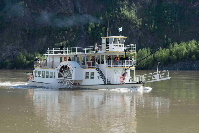
Dawson City was at one point the largest Canadian city west of Winnipeg, Manitoba. For those of you that are not familiar with Canadian geography, Winnipeg is north of Minnesota. It sits on the banks of the third longest river in North America, the Yukon, where the Klondike River enters the Yukon River. At one point there were 250 paddle wheelers operating around Dawson. They would ply the river from Whitehorse to Dawson. Today only 2 remain. The first was a rather small one that was packed in pieces over the pass from Skagway, Alaska. As one local described it was the first Ikea paddle wheeler.

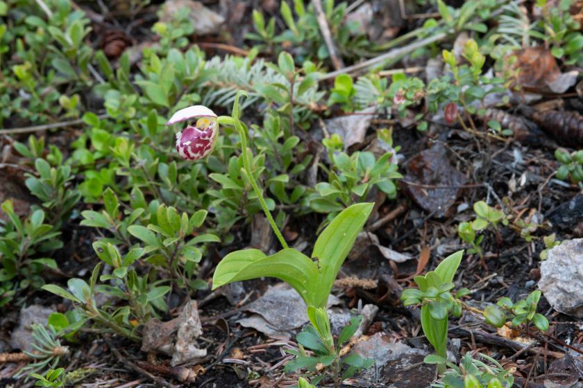
Getting back to the actual events of the day. We rose to rain and cold once again. It was not a warm rain with temperatures around 40. For my Canadian friends, 5. First adventure of the day was a hike near West Dawson where there are thousands of spotted lady slippers to be found. Well there may be thousands but we found only one. With the wet conditions I elected not to carry my camera with hopes that tomorrow we will go back.

Next, we headed to Dawson City leaving the trailer and hitch behind. There’s a strong current and I marvel at the skills the ferry captain. The loading ramps are gravel and are constantly changing as the river erodes the gravel away. They use a payloader to constantly repair the ramps. The ferry allows access to the campsite and the Top of the World Highway. The next stop along the road is Chicken, Alaska which is described as a 4 hour drive. With our trailer in tow it might be a 6 hour drive. Okay, back to Dawson. Our first stop was the City Museum located in the old court house building. Lots of old photographs that conveyed the hardships one endured living is Dawson over the years.

RRobert Service Cabin

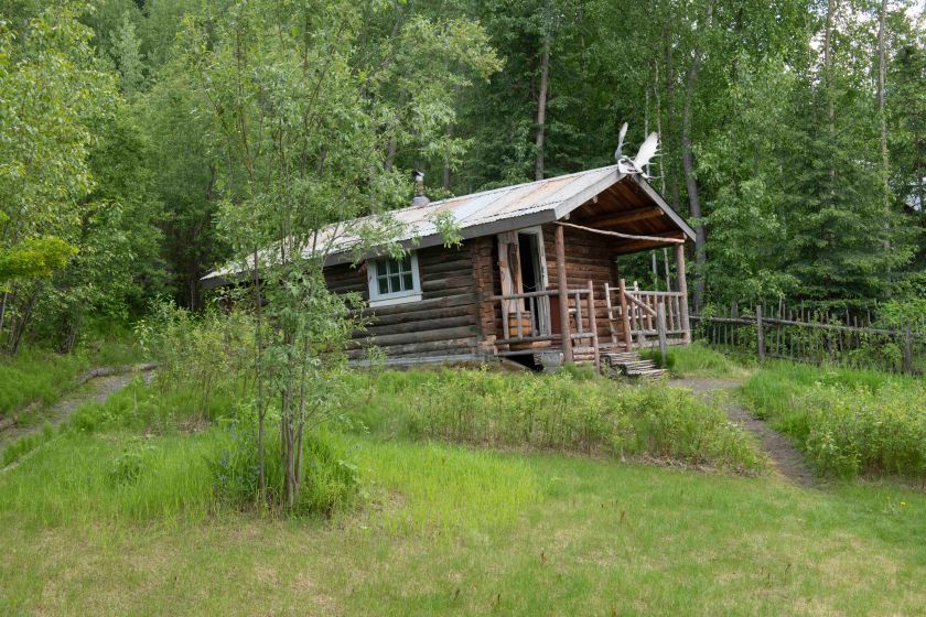
Robert Service Cabin where he stayed for 3 years writing.

Upon leaving the Museum we walked the unpaved streets of Dawson. With the rain it was a bit messy, yet when things are dry it is more than a bit dusty. Many of the old buildings exist that were built after the big fire that destroyed the town close to the turn of the century well over 100 years ago. Parks Canada is restoring many of the old buildings. We signed up for a walking tour of the city put on by Parks Canada. Our guide, Susan, was dressed in period dress and shared many interesting stories. One was about a young man who came to Dawson and rented a room at a place where the woman that owned the place had a large beautiful dog. Locally it is thought that young man based a story on that dog. It was Jack London who in the Call of the Wild wrote about a dog named Buck.

After the tour we found a nice place to grab a late lunch and headed back to the campground. We spent the time back at the campground reorganizing our load.

June 10

Carmacks, YT to Dawson City

An uneventful travel day to Dawson City. Highway 2 is a fairly narrow one that has some great scenery. We joked about taking the Demster Highway to the Artic, but it’s several hundred miles of not much. Services are few are far far between. No Demster Highway for us, at least not on this trip. Probably best not to tow a camper up it. On approaching Dawson huge piles of rock tailings were visible on both sides of the highway. The tailing are what was left after the gold was extracted. I expect that what we observed was the result of huge dredges and not individual miners. The rock piles covered a huge area.

Welcome to Dawson City

Since we will be in Dawson City for a couple of days we drove to the far end of town where the ferry crosses the Yukon River to both the Yukon Government Campground along the Yukon River and the start of the Top of the World Highway. We are now camped at the Campground across the river and just downstream of Dawson. It’s exciting that two great writers, Robert Service and Jack London lived at one time in Dawson City.

It was a midafternoon arrival at the campground and we are now set up in the far end of the large campground with nobody close to us. Plenty of privacy here. Even if it was fairly full each site is wooded and well away from each other. Crossing the Yukon on the free ferry was a treat but our hitch rides lowto the ground. The ferry crew need to place boards down so that we could drive off the ferry. With the pickup alone there is no problem. There’s no problem with the trailer either, it’s just the low hitch.

June 9

black bear 1Teslin, YT to Carmacks, YT

Overnight it started raining and did not stop until midafternoon. Our route today took us westward along Yukon 1 (Alaskan Highway) to Whitehorse, the largest town in the Yukon. It’s a busy town with all services for which we were thankful. Let me go back to the morning maybe an hour out of Teslin. We hit another section of construction where the pavement was removed and a hard gravel base was placed preparing to place new pavement on top. Well, after maybe 5 miles of this gravel base the TPMS (tire pressure monitoring system) alarm goes off. The trailer’s right tire was quickly losing air pressure. Time to break out the jack and lug wrench (neither comes with an Airstream) and change the tire. Here’s the setting: It’s raining; Temperature is 37 degrees (you read that right, 37 F or around 2.5 degrees C); There is little room to move over; There’s plenty of mud to work in; and it’s just not the ideal weather, time, or place to change a trailer tire for the very first time ever. First task was to get the tools out of the bed but they are way under the bed cover so it takes wrangling to get them. Marsha chocks the trailer so it does not slip then she checks the manual on how to jack the trailer up. That part was easy, but it was more difficult to get to the spare trailer tire underneath the trailer. Once we got that out the change was easy. Trailer has tires. Next step was to confirm the spare was up to pressure, but it was only at 50 psi. They are rated for 65 psi so we dug out the air compressor. Now to run the compressor we need to dig out the generator, start it and then use the compressor.  Next step was to put the flat tire in the truck bed. While loading it I realized the hub cover that protect the wheel bearings from dirt was still on the flat tire. That meant we needed to dig out the jack again, jack up the trailer take the tire off and mount the hub protector then put everything back together once again.

We found where a stone had worked its way into the tire causing the leak. I have a tire plug kit but felt more comfortable taking it to a shop. Thus onward to Whitehorse. First tire place could get it fixed on Monday (note to self: today is Saturday). Second tire shop could have fixed by 5 pm. We dropped it off and headed to downtown Whitehorse. First stop, the Yukon Information Center, then a late lunch at the Klondike Grill ( or something close to that). It was a great lunch. Next a bookstore and a quilt shop. After that we purchased more food supplies to hold us for a few days. Again we filled up with gas and finally got the repaired tire.

We left Whitehorse around 4:30 heading west along Yukon 1 for just a few miles where we took a right on Yukon 2 (The Klondike Trail) to Dawson City, site of the Klondike Gold rush of 1898. Gold was actually discovered fin 1896 but it took a couple of years for the tidal wave of prospectors to get there. The journey to Dawson City was long, hard, and expensive with little understanding of how many would not find any gold at all. By the time the outside world arrived most of the claims were already taken.

Heading north on Yukon 2 the first planned stop was a Lake Leberge. You may or may not have read of the Scottish poet, Robert Service who wrote so much about the Klondike. He authored, The Cremation of Sam McGee, where Lake Leberge was the setting for Sam McGee’s cremation. My mother read Robert Service to me when I was young and he has held my fascination my entire life. Marsha suggested we stop and take a photo of me next to Lake Leberge. Great idea, but we missed the turn and there was not a place to turn the truck and trailer around for the next 10 miles. Northward we headed. We stopped at a Yukon Government Campground only to find it full. Being the weekend and not too far from Whitehorse both tourists and locals are out enjoying camping. We pushed on to Carmacks where we are camped for the night. The good news is that late in the day the sun came out and the temperature warmed.

June 8

Laird Hot Springs, BC to Teslin, Yukon

We considered another dip into the hot springs but the thought of walking back in 42 degree weather after soaking in the hots springs was enough to give us second thoughts so me pass on them today. Once underway the wildlife sightings continued. First another wood buffalo then a red fox, more buffalo, topping off the day with 4 black bear sightings. The road was nice but not full of climbs and twists as we experienced yesterday. After a bit we arrived in Watson Lake, Yukon. This is home to the Signpost Forest. Back in 1942 a huge push was underway to create a land route to Alaska. US war planners looked at a map and realized the western part of Alaska was only 1,000 miles from Japan and neither the US or Canada wanted Japan to gain a foothold on North American soil. This was the push and the rush to create the highway. One of the construction workers in the Army was homesick so he constructed a signpost with how far to his hometown. On the same signpost there were about half a dozen signs from fellow US military highway workers Many mistakes were made in building the road but over time most have been corrected with rerouting and grade improvements.  The Alaskan Highway is paved and in decent shape. There are sections of construction so we have hit some dirt/gravel sections in construction zones but overall it’s been less than 5 miles of it.

Each year there are thousands of new signs added to the forest. We spotted several from around New York State. I spotted one from Schnectady that had had the name of a couple. She knew them from when she worked in Cooperative Extension in Schnectady.

After the Signpost Forest we headed on to Teslin, Yukon where we are camped at a campground. In the morning we need to get ice, gas, and propane then head to Whitehorse, the largest town in the Yukon.

June 7

Fort Nelson, BC to Laird Hot Springs, BC

Upon leaving the campground we ran errands in Fort Nelson with stops at the grocery store, visitor’s center, quilt shop, and gas station. We are keeping well stocked with supplies as we head towards the Yukon where prices will increase as selection will decrease. That’s not a totally true statement since there is at least one large town along the way.

The traveler that mentioned plenty of wildlife up the road was right. Within half an hour heading north we spotted our first black bear and by the end of our day’s journey we saw three more black bears, a caribou, a moose and her calf, stone sheep, and wood buffalo (wood bison according my traveling environmental educator.)

Not only did the wildlife put on a show so did the scenery and the character of the road. Plenty of mountains, river crossings, steep grades up and down, and twists and turns added to great travels today. We decided we it was to be a somewhat short travel day covering around 200 miles. We stopped sometime around 3 pm at Laird Hot Springs, a British Columbia Provincial Park. It has a beautiful hot springs. It is natural setting where you walk about ¼ mile on a boardwalk over wetlands to slow free running stream. Head upstream in waist deep clean water and the temperature goes north of 120 F or downstream where it finally cools down to maybe 90 F. It is a beautiful setting!

June 6

Mile Zero of Us
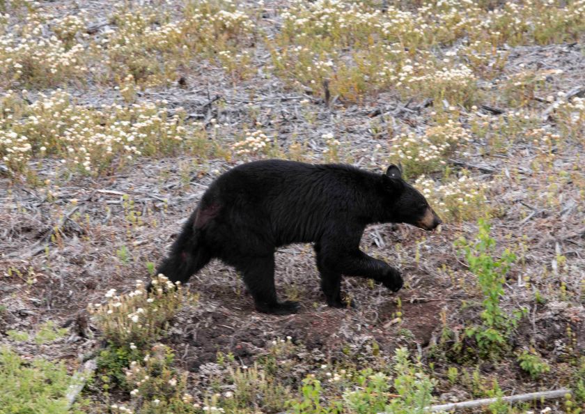
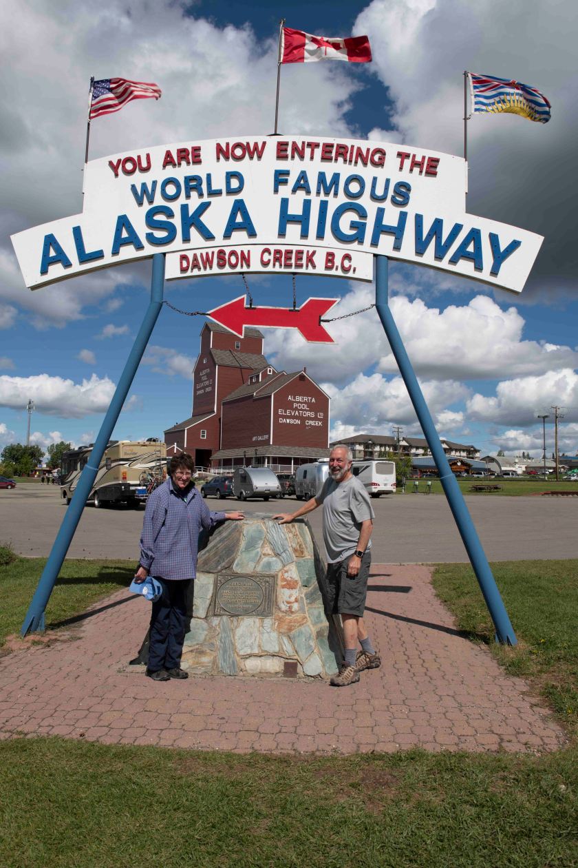
West of Grand Prairie to Fort Nelson. The big story for today is reaching Mile Zero of the Alaskan Highway. We took the necessary photo of us at Mile Zero only to discover that was the new sign. The original Mile Zero is two blocks away. Off we headed to get that shot as well and find a bakery. Success on both accounts. Dawson Creek is know as mile zero yet the traffic was heavy. RVs, pickups, big trucks, and even a few cars clogged the road. It took about 30 miles along the route to clear traffic. Stopped tonight at a campground in Fort Nelson, BC. A car coming the other way hit a white tail deer. Other than that towards the end of the day Marsha spotted a black bear. I just spoke with another camper and he said the next section of highway has lots of wildlife.