Dealing with even Sunday morning traffic in Seattle is not fun. We visited with our friends for most of the day with much of the time spent just catching up. We did go for a little walk along Puget Sound then back for supper at their place. Another first, where we actually drove with it dark outside. We have not driven at night since leaving home back in May. Tomorrow we head toward Olympia to visit a friend who was part of the Karner Blue Cloggers. This was a clogging group Marsha was part of back in the early 1980’s.
August 4
Heading to the Seattle area today. In searching for a place to call home for two nights we’ve had no luck close to where our friends Lydia and Bob live. Their place , is not accessible with the trailer. Thus we need a place for tonight where we can leave the trailer tomorrow morning then spend tomorrow night there as well. We lucked out and found a place to stay with the drawback that it is and hour south of Lydia and Bob and well south of Seattle. This is the first day we have dealt with traffic since leaving home.
August 3
Another travel day as we plan on visiting with friends in Seattle on Sunday. We ran into Wezzie and Robin two more times today. They are heading down west of the Cascades while we are heading south on the east side. In southern BC we saw a forest fire. It was not threatening for us but did fill a huge valley with smoke. We stopped and purchase fruit but needed to consume it before reaching the US. The apricots, peaches, strawberries, and cherries were great! Tomorrow we’ll try to restock on fruit since we are now sans fruit. About 440 miles today as we are now stopped in Oroville, WA.
August 2
A travel day, from Hyder, Alaska to Hixon, BC about 475 miles. This was likely the longest we traveled in a day for the entire trip. We spotted a few black bears and eagles but not much else for larger wildlife. The views remain outstanding.
As heading along the highway we spotted our next door neighbors from the campground in Hyder. They were pulled off the road taking a driving break. If we had seen them just a bit sooner we would have stopped and visited. They are two photographers from Ohio, Wezzie and Robin. Traveling past Prince George they passed us and waved. We followed them for 20 miles until they pulled into a campground while we went another 25 miles.
August 1
Cloudy and a bit cooler today. For most of the trip the weather was on the cool side with many showers yet for the past two to three weeks it’s been warm and no rain. The highest temperature we’ve seen on the trip was maybe 80 but usually in the high 70s. Here in Hyder the salmon are at the mouth of the river with only small numbers heading to the spawning grounds in the smaller streams. The bear viewing area here is along a smaller stream where only a few hundred chum salmon have come. Thus the bears are not showing up yet. They will most likely be here soon but probably after we head south.
After checking the bear viewing area with no bears there we came back and did some chores. It was time to reorganize the back seat cab area of the truck where my photograph equipment is stored. As I’m pulling things out, sorting and repacking I pulled out the box where I have my dead Nikon D850 camera body. For laughs I stuck a battery in it and it fired up. After some test shots I found it to appeared to be working!!!! I’ll test it a bit later today and find out if it is really working.
Once all is packed away we head to Stewart for a hike on trails near town. We start with a boardwalk over the marsh at the head of the Portland Canal. There we meet Mary and Bob from Wala Wala, Washington and Kay and Douglas and Kay from Colorado. Conversation ranged from photography to birds plus more. After this Marsha and I headed on the Big Spruce Trail that went into some very large spruce. It was a cool trail and as we got further from town the more bear scat we found. Time to turn around. The spruce were truly large. We estimated it would take 10 to 12 people holding hands to encircle one of the large spruce trees.
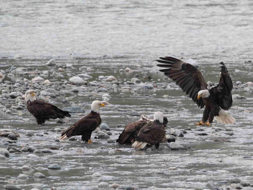
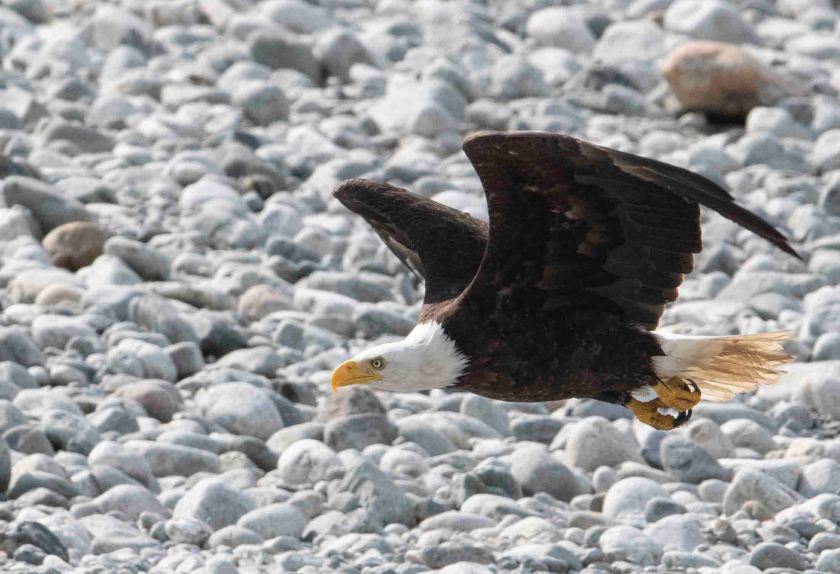
Back in town we grab lunch at Temptations, a great bakery and café. Heading back to Hyder we checked out the marsh and saw one black bear with a cub. Sorry, no photos of the bears. Next back to the bear viewing area and still no bears. I dropped Marsha off at the campground while I went out to photograph putting my “new” camera to the test. Only a quarter mile from the campground I spotted several eagles along the river. I stopped and photographed them for half and hour getting some great shots. Back to camp and I find the camera is fully functional. I am thrilled! A note, as I write this I can hear eagle cries. It’s a sound that I love hearing.
July 31
Up early to go to the bear viewing area, but no luck. The road beyond Hyder climbs to Rainbow Glacier about 33 miles up a gravel road. We drove up and got some great views, but the road is narrow and dusty. Did I mention the road is dusty? If not, I should. It is dusty!
Back to the campground where we meet our next door campground neighbors, Kathy and Gordon. They live in Hinton, Alberta in the foothill of the Canadian Rockies. We swapped stories and photos. They have amazing photos of grizzlies from back home. Next we head to the bear viewing area for evening viewing. No luck but at least we looked. Plenty of eagles around but no bears.
July 30
The campground was full mostly by a caravan of RVs. Twenty-two big rigs n the group. These are professionally operated trips where all the organizing is done by the company and you bring your rig. You pay for them to lead and organize. It’s bit like going on a cruise ship but you need to bring your own room. We found their next destination is the same as ours, Stewart, BC/Hyder, AK. Before that we have an empty bottle to find.
I had remembered that we accessed the railbed about 20 miles south of Dease Lake where the bed came within 200 feet of the road. Let me start that the road may or may not be in the same location. The old highway was gravel and now it paved the entire length. The forest has grown 30 years and looked vastly different. At least different from the forest of my memories. When we located the railbed it was way off in the distance where it was not accessible. There small lakes, wetlands, and muskeg between us and the railbed not to mention there was no place to even pull off on the shoulder. There was no shoulder, just a drop off. I’d like to say we recovered the bottle but we did not. We didn’t even find a place to get onto the railbed. Oh well, it was a good dream. I will remain guilty of leaving the bottle.
We headed toward Steward/Hyder trying to avoid the caravan of RVs. We find a campground in Hyder, Camp Run A Muck. It’s small and funky. In a way it lives up to the name, yet we are in tree and it’s a beautiful location. Hyder, Alaska and Stewart, British Columbia are somewhat unique. The way here is via the one road coming off the main highway maybe 30 miles. The road heads into Stewart at the far end of the Portland Canal which is a long fjord. Hyder is just 3 miles down the road next to the Portland Canal. It’s in the US but the only access is via Canada. Heading back to Stewart you need to pass through Canadian Customs yet there is no US Customs. I decide I want to head back to Stewart to buy a couple of supplies while Marsha stayed in the campground. I pull up to Customs. “What is the purpose of your trip to Canada?” I answer with, “To buy ice cream.” I chatted with the guard for a minute and was on my way.
Why head to Hyder? We visited Stewart/Hyder at the time we did the mountain bike trip near Dease Lake. We had camped in Stewart then “bicycled to Alaska.” Back then Hyder was a hole in the wall with just about nothing but a bar. The road follows along the Portland Canal where we had seen some of our first eagles in our lives. There’s been some development of the port for the mining operations, but the main attraction for tourists to come to the area is a bear viewing area just two miles outside of Hyder. The Salmon had started running but the bears have not come. Both brown and black bears can be seen there, but this summer so far only a black bear sow and cubs showed up once. The salmon have started into the large river but the bear feeding frenzy starts once the salmon head up a small creek at the viewing area. The salmon have started but not in the numbers to attract bears. It will maybe happen a couple of days after we leave Hyder.
July 29
Travel day again. We did a longer drive covering more than 375 miles from Carcross, YK to Dease Lake, BC. We did not see any large mammals but did see several grouse. Why did we push on to Dease Lake? Well it could be a long story but let’s see how I can sum it up.
The story starts back in the 1970’s. BC Railway was building a railroad from St. George, BC to the Yukon. I’m not sure of the planned destination but my guess is Whitehorse. It’s several hundred miles between these two small cities and lots of nothing in-between. For those not familiar with British Columbia geography St. George is about half way up the Provence in the eastern part of BC. To get to Whitehorse the road route choices are from St. George to more or less head north then west or to head west then north. The planned railroad cut a diagonal across BC saving lots of miles. The difficulty was the remoteness of the planned route. They had laid railbed but no tracks all of the way to Dease Lake. They had maybe two hundred miles to go with the bed, but in 1977 project funding was stopped just three days after a major bridge was completed over the Stikine River. Hang in there, there is a point which I will be getting to in a bit.
Fast forward a decade or so to the later 1980’s. Marsha and I along with our friends Everett and SC; and DeeJay and Kerry planned a mountain bike trip starting near Dease Lake heading southeast along the old railroad bed. This was not a walk in the park or rather a ride along a bike trail but more of an adventure. We did not know of anyone attempting this ride before us. So the three couples meet up in Dease Lake and arrange to leave our cars for just under two weeks. We located the railbed about 20 miles south of Dease Lake where the bed comes close to the Stewart Cassier Highway. We got a late start but we were off for Day 1. That first night we camped along the railbed and somebody had carried a bottle of champagne which we enjoyed celebrating the completion of our first day. An empty champagne bottle is heavy so we built a rock carrion with the bottle in the middle. Our plan was to pick it up on our way out in about 10 days. Day one was great, but it was not the case with day two. Day two started out okay, but soon the mud started gumming up our wheels until they stopped turning. We stopped a few times to clean out the mud. Maybe finding a pair of abandon bicycle fenders should have been a sign. We pushed onward finding washouts along the railbed. These washouts involved carrying our bikes and gear down step slopes with drops of maybe 150 feet, across a small stream and back up the other side. This got old after maybe the third washout. Maybe it was old after the first washout! Anyway Day Two was hell. We crossed over the Stikine River on the bridge I mentioned earlier and camped. The next day we discovered there was a small dirt access road from the highway to the railroad bed being maintained (I use the word “maintained” very loosely!) for fish camp access. Eventually the road was blocked not allowing vehicles to pass but we could continue on with bikes. The rest of the trip went great but when it was time to turn around and head back to Dease Lake there was no way we wanted to repeat Day Two so we used the access road to return to the highway maybe 5 to 10 miles away. We never returned to pick up the bottle.
We wanted to find it and bring it back. Thus the reason for heading to Dease Lake. It’s a bit like looking for a needle in a haystack or more accurately a champagne bottle in a wilderness. So we are at a campground in Dease Lake. Tomorrow we’ll start the hunt.
July 28
Skagway, Skagway, Skagway. How do I talk about Skagway? Well, before jumping in let’s backtrack a bit. Up in the morning packing what we need for the day leaving the trailer behind we head south the 65 or so miles to Skagway. The landscape starts out as spruce trees like so many other places up here. As we approach the US border we discover there’s close to 30 miles of no mans land. We passed Canadian Customs and drive for 30 miles before we hit US Customs. The landscape between these to border crossings is surreal. Many say it’s more like the moon surface then just about any other place in the world. I’m not sure of that since there were a few tiny spruce trees yet it’s a mountainous barren land. The landscape reminded me of the area surrounding Sudbury, Ontairo in the 1970’s. Sudbury had the world’s largest nickel smelter putting killing the forests for miles around. We drove over White Pass the same White Pass that has the White Pass Railroad. More on that in a bit. We get to US Customs. “Any fruits or vegetables to declare?” We reply with no. Then we are informed we are randomly selected for “additional screening.” Translation, we are going to search your truck. We go and park where directed and come inside to the waiting room. As we are walking into the building we remember the fresh British Columbia sweet cherries we purchased in Whitehorse. My thoughts jump to getting into hot water for not declaring them while Marsha was much cooler saying we just tell them we forgot to mention the cherries. We get to the desk and fess up about the cherries and receive a no problem, but declare them now. We then waited maybe 15 minutes while they searched the truck. The only painful part of the wait was having to look out to two large photo portraits on the wall, one of the president and the other the vp. We are free to go and head into Skagway.
What is it about Skagway that makes it such a dichotomy? Let me start with a bit about its history. When gold was discovered near Dawson City in the fall of 1896 word got out to the world in 1897. The world was still in a global depression and the news of a huge gold strike was shouted around the world. All one needed to do was to get up to Dawson City, Yukon and pick up huge gold nuggets. Get rich so easily! People came from around the world seeking their fortune. The educated, the rich, the poor, the farmers, the factory workers, the homeless, and more. They all headed to Dawson City to seek fortunes. How does one get to the Yukon? There are various routes including taking ships and river boats from the US West Coast north, through the Being Sea to the Yukon River and up that river more than one thousand miles. Only the wealthy could afford to do the all water route when it was not iced over that 8 months a year. The next best way and the only affordable way was to take a ship up to either Dyea or Skagway. They are about 8 miles apart. From there one just needed to walk over the mountains 35 to 40 miles to Bennett Lake, build a boat and float your way over a couple of lakes and down the Yukon River to Dawson City. It’s an easy trip, or so it was reported. The misinformation was spread to entice would be miners to take either the Chilkoot Trail out of Dyea or the White Pass Trail from Skagway. At the top of the pass the miners would leave the US and enter Canada. The Northwest Mounted Police were at the top of the passes not allowing anyone to enter unless they had a year of supplies with them. A year of supplies is well over a thousand pounds. Both passes were difficult and many lost their life on those trails. The would be miners needed to take 20 or 30 trips up over the pass getting their supplies up before being allowed into Canada. As one trudged up the pass with a load on his back (their were some women that did this journey, but the vast majority were men) if one stepped off the trail they may need to wait hours to get back into the line. The trail in the winter was carved ice steps. The debate raged which trail; White Pass Trail, or Chilkoot Pass Trail was easier. The answer was always the other pass, cause this one was hell. One vet of the gold rush described one trail as Hell and the other, Damnation.
The towns at the start of the trail were not safe places. The “bad guy” leading the crime against the newcomers was Soapy Smith. He was shot in the early 1900’s with the person killing him becoming a hero.
Both Skagway and Dyea were Tlinget clan communities. They hired out their services packing supplies up the passes but many of the newcomers could not afford them. It cost an individual maybe 3 oz of gold to have supplies hauled up the pass. That may translate to maybe $5,000 today. Many Klondikers lost their lives on the trail.
Anyway, Skagway was on boon town with maybe close to 100,000 people trying to get to Dawson City. There is history and lots of it. Jack London, writer of Call of the Wild traveled along the trail from Skagway. Skagway seems like an exciting place to visit, and don’t get me wrong, it is. Why the hesitation on visiting Skagway? Skagway has maybe 2,000 residence yet up to five large cruise ships come into port on any given day during the season. That translates to 10,000 people descending upon Skagway each day. One shop keeper said, don’t come on a Tuesday or Wednesday. “If you step off the sidewalk the sea of people is so great that you’ll need to wait to get back on it again. Much like the Klondikers stepping off the trail back in 1898. The weekends are the slow time, so if you are not on a cruise ship visit Skagway on a Saturday. Much of downtown Skagway is a National Historic Park and it’s run very well by the Park Service. The downtown has wooden sidewalks and shops. Shops, shops, and more shops. Most of the shops are owned or associated with the cruise lines. How many high-end jewelry stores sell diamonds can a town of 2,500 support. We saw at least five of those. Well we saw them only from the outside. The key to shopping in Skagway for us was to go into the “locally owned” stores.
After a Ranger led program we explored a bit of the town then headed over to Dyea, eight miles away. The town no longer exists, but there is a cemetery where many who died on the trail were buried including around 100 who perished on Good Friday, 1898 in an avalanche.
I have mixed feeling about visiting Skagway, but in the end I’m glad that we did.
July 27
A travel day today from Haines, AK to Carcross, YT. Not much to say about today other than we made it to Carcross staying at a small government campsite. We stopped in Whitehorse for supplies then on to Carcross. A bit about geography, Skagway is maybe 15 miles via water from Haines yet by land it’s close to 350 miles to drive via land. We did not have ferry reservations so we drove around.

The view from our campsite in Haines
