Tuesday April 16 – Antelope Canyon

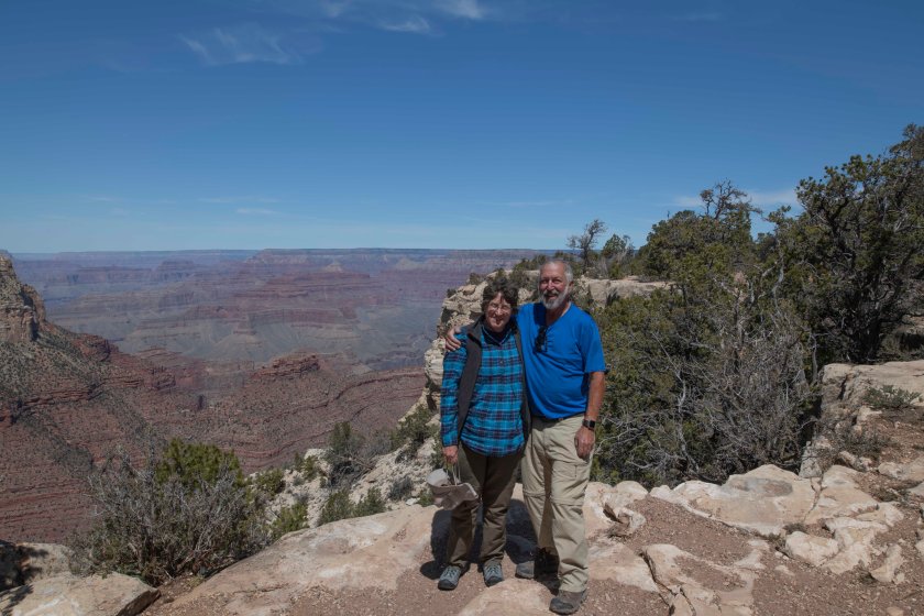
In the morning we head to Horseshoe Bend a couple of miles south of Page. Here the Colorado makes a horseshoe like bend in the river and one can view it from high on the cliffs above the river.

We’re signed up for a photography tour with one of the tour groups that brings people into Upper and Lower Antelope Canyons. Access to the canyons is highly controlled. In order to get in you must be with one of the tour groups. Wells was aware the it can be crowded and was more looking to experiencing the canyon rather that expecting a great photography experience. We have reservations for a 2:30 Photography Tour of Upper Antelope Canyon and Rattlesnake Canyon. Wells does not have high expectations since there’s are some rainshowers and the light is not bright. With the photography tours with the company we signed up with there are 7 different tours.

Photograph tours require a high end camera and a tripod. Point and shoot cameras are not allowed. All but two of the seven different Photography Tours do not permit non-photographers. We are signed up for one where each photographer is entitled to one non-photographer to join in on the tour. We are doing Tour 7 which is two canyons. As luck with have it we are the only two on this tour so we take off with our tour guide, Albert, and head to Antelope Canyon. If one is not on a photography tour you are allowed a camera or camera phone but no bags, tripods, or selfie sticks. We enter into the canyon and Albert clears the way so Wells can shoot. He recommends different locations and even camera settings. Wells gets some great shots then moves to the next spot in the canyon. All the tour guides do a great job of clearing the way for the photographers to shoot.

After an hour or so in Upper Antelope we pile back into the tour’s four wheel drive and go to Rattlesnake canyon. The contrast between the two canyons is amazing. Antelope has tall walls maybe 50 feet or more. One mostly does not see the sky from Antelope while Rattlesnake is smaller with maybe 20 foot walls and often the sky is visible. It’s narrower in many spots as well. While Antelope has hundreds of people the three of us are alone in Rattlesnake Canyon. It’s a special place.

Expectations for Wells are highly exceeded for both canyons.

Tomorrow we are heading west to Kanab, Utah.

Monday April 15

We pack up camp and head back into the Park which we travel though on the way to Page, AZ. We set up camp at an RV park in Page. The campsite is close where we have an reservation of a photo tour of Antelope Canyon. More on that once we do the tour tomorrow afternoon.

Once set up we head west on Route 89 towards Kanab, Utah. We stop at a National Monument Visitor Center and inquire about driving to White Pocket. White Pocket is a dramatic number of twisted bedrock way off the beaten trail. We had traveled to White Pocket two years ago and hoped to return. We find that the roads are passable yet only by 4 wheel drive high clearance vehicles. Our Ford F150 meets the requirements so we get directions. Basically, it’s down the paved road 10 miles then about 20 miles on gravel miles. The report on this road is about 10 miles of graded road in good shape then 10 miles of road extremely rutted and in very rough conditions. The last part is a series of one lane sand roads in rough shape. This part is maybe 15 miles. We find the report on road conditions accurate.

Shortly before we reach the parking area for White Pocket we encounter three vehicles; a jeep parked in the road in front of us heading in the same direction; a All Wheel Drive car facing us but buried to the undercarriage in sand pointed in our direction; and another pickup behind the car. There is no way to get around the vehicles on the one lane sand road so we stop and offer to help dig the car out. After half an hour the car is jacked up and sand ramps are under the front wheels. With all of us pushing the car is out of the sand. The person is lucky since it would have been several hours and lots of cash to get towed out.

With the delay in our traveling to White Pocket we only had twenty minutes to enjoy the scenery and photograph then we turn around and reverse our trip for the two hour plus trip back to the camper.


Sunday April 14

We’re camped in the National Forest a few miles south of the Grand Canyon South Entrance. There are a few other campers scattered about but the closest to us is a quarter mile away. It’s a peaceful spot. The forecasted low overnight was the low forties yet when we wake up the inside trailer temperature is a brisk 36 degrees. Time to turn on the heat. Ninety nine percent of the time Wells makes the coffee but with the cabin so cold he’s not moving yet. Marsha, the wonderful person that she is gets up and makes the first pot of coffee. Slowly the cabin warms and we enjoy our hot coffee.

We are on to the big hole in the ground just north off us. We head to the main Visitor Center then hike the Rim Trail west to Grand Canyon Village maybe two miles away. The sun is still relatively low and light and shadows show off the canyon. The first half mile from the visitor center is crowded and the further we go the more the crowds thin. There are more crowds as we get closer to Grand Canyon Village. The views along the trail are breathtaking.

The afternoon has us driving the park road 25 miles east and the views continue to be breathtaking.

We arrive back at the camper and enjoy a bit of reading and nap time then we break out the grill and enjoy a salad and pork chops.

Saturday April 13 – On To Grand Canyon

Saturday April 13, 2019

The plan for today is to drive into Flagstaff and do a few errands then onto the Grand Canyon. Last night the weather was cold with rain showers. We didn’t talk with any other campers since all were hunkered down in their trailers just like us. This morning it was a task just getting out of the campground. A very pleasant task actually. We are in our truck driving around the campground to get to the exit when Wells spots a map on the inside of a camper door. It’s exactly like what we are looking for. The map is of the United States and Canada with the outline of each state and province. It has stickers for each state and province that you put on the map once you travel to that state or province. Wells stops the truck and asked where they found the map. That leads to an interesting conversation with Brian and Tammy. Next we see a couple with a Scamp trailer. Wells had chatted with the man, Bob, earlier in the morning so we stop to get a tour Bob and Marcy’s trailer. Again the conversation goes on. Next it’s on to the dump station. We finally leave the campground after more than 45 minutes after leaving our campsite.

In Flagstaff it’s first to REI to get a few camping supplies and new hiking boots for Marsha. Next stop is Whole Foods to pick up food supplies. Final stop is a hardware store where we pick up a couple of small items.

We are out of town and heading to the Grand Canyon. We first park the trailer in the National Forest where we will do some boondocking. Once the trailer is dropped it’s on to the National Park. We head to the visitor center first in order to orient ourselves on what to do. We attend a ranger lead program on the California Condor and the efforts to pull them back from extinction. Last summer there were four condor nests in the park and those nests produced two chick in the wild. Not big numbers but still it’s more. There may be as many as 400 living condors up from just 22 in 1982.

It’s around 5 pm now and we drive eastward along the south rim road and enjoy the majestic views of the Grand Canyon. We arrive at our trailer shortly before sunset and unwind. The temperature is around 50 but we expect it to get below freezing tonight.

Marsha and Wells at the Grand Canyon

Friday April 12 – To Winslow

We bid Kathe and Stan goodbye and head out. First stop is a Tucson RV Store that offers a free dump station since our black/gray tank is nearly full. We pick up a few items at the store, use the dump station then north on two lane roads with our goal being National Forest campground about 40 miles south of Winslow. After a stop to purchase a propane refill, the second 20 pound refill of this trip, we travel northward on scenic Arizona highways along meeting a few rain showers. These are the first rain showers on this trip since day one heading to Virginia.  Throughout the day the temperature drops. By the time we are climbing into the National Forest the temperatures are in the low forties and we are over 7,000 feet elevation. Snow is on the ground in patches and we are beginning to wonder if the campground is even open. Next there’s a sign that says all the Forest Roads are currently closed. By this time we realize we are not staying where we thought so we push onto Winslow. There we find a State Park about 3 miles outside of town. The temperature is now about 50 due to the lower elevation but it’s going to be a cold one tonight. Tomorrow we head to Flagstaff then the Grand Canyon.

April 11 – Sabino Canyon

Roadrunner 1
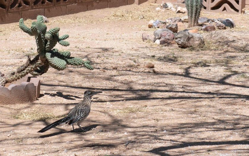
We have the camper parked in Kathe and Stan’s back yard. Wells is enjoying his coffee at the table in the camper still wearing a bathrobe and Marsha is sitting up in bed enjoying her coffee there when we begin hearing a weird loud burst of low pitched noise. We both ignore it at first but it gets louder and louder with each burst. Wells opens the camper door and very close just over the shrubs in the backyard is a hot air balloon. While still at the table Wells grabs his camera and takes a photo of the balloon. After that excitement and we are still enjoying our coffee when Wells looks out the camper door and near the steps is a Roadrunner staring back at him. The Roadrunner runs maybe 30 feet before Wells takes photos of the bird.

Balloon 2

After a few chores we head to Sabino Canyon for a hike. It’s a resource close to Tucson that has miles of hiking trails in the desert and up various canyons. We pick Bear Canyon and do a 4 mile hike. The birds and desert plants in bloom are such a joy. With temperatures in the upper 70’s we still know we are in the desert from the wind, sun, and dryness.

Back at the house we make dinner and enjoy conversation with Stan and Kathe.

April 10 – Tucson

After a night in the National Forest we head out of the mountains and head into Tombstone, AZ to check out the town. We are lucky and don’t get into any crossfire or gunfights. Now it’s on to Tucson to visit with Kathe and Stan. Our choices for travel are: North back to Benson and west along Interstate 10; or West from Tombstone and north towards Tucson avoiding an Interstate. It’s an easy decision and we take the road less traveled. Once in Tuscon we find Kathe and Stan’s place with no difficulty. It’s somewhat secluded yet more urban than their place outside of Fairbanks.

We park our trailer and head to the western part of Tuscon to the Arizona Sonoran Desert Museum. It a great place. lt has both desert animals and plants spread out over a large site. One is in the desert and can see forever yet it’s not possible to see one exhibit from another. It’s an interesting world. We are in an outdoor hummingbird house. Next it’s a bird aviary. In the bird aviary it’s designed for you to see the birds up close yet they are surprisingly difficult to see at times. The cactus gardens are natural and beautiful. Many of the desert plants are in bloom. Next we see desert big horn sheep and other larger desert animals. It’s a great place to visit.

To get to and from the Museum the road heads over a low pass that is loaded with Saguaro Cactus. They grow on slopes and at the base of mountains. They are just beginning to bloom.

Once back at Stan and Kathe’s we are treated to a delicious steak dinner.

April 9 – Benson, Arizona

We’re heading to Tucson to our friends from Alaska Kathe and Stan. We visited with them last summer in Fairbanks. For the past few years they winter in Tuscon. We plan to arrive tomorrow yet we don’t have a long distance to travel. We decide we’ll look for free camping somewhere not far from Benson, Arizona. Our friend, Michael, who we’ve not seen in over 30 years lives in Benson. We contact him and we meet for lunch at the Horseshoe Café. Great place for lunch. Michael wanders the natural environs to experience the nature of things and suggests the Dragoon Mountains south of Benson not far from Tombstone. He offers to lead us there into the National Forest.

With the temperature in the nineties in Benson we look forward to cooler temperatures in the mountains. First, it’s several miles south on pavement then ten miles of gravel road over ululating desert which slowly climbs in elevation. Next, we hit the mountains and the road climbs the temperatures moderates to the high seventies.

After a few challenges in finding a suitable location to camp we arrive in the woods. It’s beautiful all around. Soon we thank Michael and bid farewell and he treks back to Benson. Once we set up out come the cards and beverage as we enjoy our surroundings.


April 8 – Gila Cliff Dwellings

April 8 – Gila Cliff Dwellings

In the morning we take Lori’s car down the mountain to Silver City. We arrive in less than half the time it took us to drive up with our rig. From Silver we take a two hour drive to the Gila Cliff Dwellings. The trail to the dwellings is a one mile loop with a fair amount up and surprise surprise and equal amount back down to the parking lot. Before we are allowed to begin the trail we need to have the rules explained and we are required to adhere to the rules. Must carry water up; must not have any other food on your person including anything fully wrapped; cannot be chewing gum; cannot go off the trail; and can only go in specific areas within the actual cliff dwellings. The rooms accommodated roughly 40 to 60 people for only about 25 years around 1300 AD. Here a group of people could meld their lifestyle with the surrounding environs.

After the adventure we headed back to Silver where we enjoyed one of the art centric town’s restaurants.

April 7 – Mexico

Marsha and Wells at Columbus
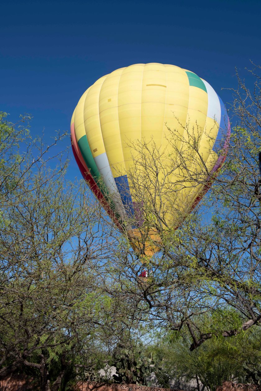
Our friend, Lori, lives more than an hour north of Deming outside of Silver City. We arrange to meet at Walmart in Deming where we can leave our Airstream for part of the day. Previously Wells asked Walmart Management if it was okay to leave the trailer parked for part of a day. He was told that is was okay to leave it there as long as needed and there is no need to tell them that you are doing so. It is a nice service the company offers at many locations around the country. In previous travels we often saw many Rv’ers parked at Walmart overnight.

Lori arrives and we meet up. We pile into her car and we head south to Mexico. Our destination is, “The Pink Store” just over the border from Columbus, New Mexico. Columbus, New York is our hometown so we pile out of the car in front of a Columbus sign and Lori takes our photograph. We park at the border on the US side and walk into Mexico. We need to walk through an official building but nobody asks us any questions or asks for any identification. Once past the border we walk the one block to The Pink Store.

The Pink Store is a shopping destination for US tourists. It has Mexican wares that run a wide gamit including glassware, dishware, garments, and other colorful choochkies  As you shop they serve you free margaritas. Yes, free margaritas. It’s an interesting sales enhancement technique. We each enjoyed on free one then we sat down for lunch at the same place while a group of Mexican musicians performed. After lunch we purchase some things and head back to the US. Each of us carry one bag full of items and at the US border we hand the guard our identification documentation, Lori, passport while Marsha and Wells each have enhanced licenses. Not one question asked of any of us. The guard did not ask where we had been or what we had done. He didn’t even ask what was in any of our bags. It was the easiest border crossing process that Marsha or Wells had ever experienced.

We head north towards Deming but Lori wants us to see a small state park about 10 miles out of the way. We drive in and at the end of the road sits Dawn and Scott’s car. No sign of Dawn and Scott so we leave a note on their car and we continue heading north to Deming where we pick up our truck and trailer and head northward towards Silver City.  Shortly after reaching Deming our cell phone rings and it’s Dawn. She was sitting near the car at a picnic table when we left the note on the car. We will see more of them at some point in the future.

Lori lives up over a mountain 12 miles outside of Silver City on let’s just say an adventurous road. The 12 miles takes us more than an hour. At last we arrive safe and sound at Lori’s.