Saturday April 26 – to Black Mesa State Park in Oklahoma

The sun is fairly high in the sky once it crests the tall mountains just east of Great Sand Dunes National Park. The tallest peaks in the area are over 14,000 feet. The shadows on the dunes from the sun don’t inspire Wells so we are off late morning heading for Oklahoma. Before leaving we meet an interesting couple, Kathy and Bob who are on their shakedown camping trip in their new to them camper van. They are updating their list of what to bring and what not to bring in their camper. That was us not that long ago.

Leaving the park we head south and to the pass over the mountains that leads to the plains. Although the pass is fairly high it’s not a difficult climb. Once on the plains great views of the majestic mountains remain visible and gradually fade in the hazy distance. We first head south then east. We’re zeroing in on Oklahoma and a state park in the extreme western part of the Oklahoma Panhandle. We pull into Boice City, OK and now head due west maybe 35 miles to the state park. The does not continue any further west so we are way out there!

Friday April 25 – Great Sand Dunes National Park

One additional camper entered the campground after we went to bed last night and we didn’t notice them until the morning. We stayed at a great spot. Originally Wells thought we camped well below the snow line but in the morning we saw plenty of snow in the woods. Also there was a heavy coating of ice on the cover to the truck bed while we stayed cozy in our camper. We are enjoying it getting cold inside the camper at night and then flipping on the heat before we get out of bed.

Today’s an easy drive to Great Sand Dunes National Park. Since it’s Friday we expect several campers will be arriving later in the day for the weekend so we arrive midday and have our pick of several empty sites. This is the first overnight camping we are doing in a National Park on this trip. The sites are small and are suitable for big rigs but our 16’ trailer is perfect for this place. Between 3 and 4 PM the campground fills up yet people continue to drive in hoping for an empty spot.

Earlier in the day when we first arrived in the National Park Wells asked a Park Ranger for advice in photographing the sand dunes. He consulted the up to date weather forecast which called for 25 mph winds and thunderstorms. He advised Wells not to go out in the dunes later today since the conditions would be difficult. Wells took a wait and see approach on photographing later. He does take some photos of the dunes from outside of them with a longer lens, 70-200mm with positive results. Plenty of storms moved in and prospects become less promising. With luck later in the day the wind is not as strong as predicted so there is not the feared blowing sand so Wells heads out an hour before sundown.

With decent light he gets some he is happy with for now. We have a few conversations with fellow campers then hit the hay.


Tuesday April 23 – Moab

Moab is an interesting place. Wells thinks of Moab as a cross between the tourist town of Jackson, Wyoming and Kanab, Arizona. All three places have a harsh and breathtaking beauty surrounding them with tourist based economies. Jackson is congested and trendy so much so that it can be overwhelming while Kanab is much smaller and more laid back. Moab is in the middle. Beyond Arches and Canyonlands National Parks Moab appeals to both the off-roading jeep crowd and the mountain biking crowd. Moab is a mecca for both activities.

Once we secure a campground site we head out to Arches National Park to orient ourselves. Then it’s back to town where we enjoy an outstanding Thai lunch at Arches Thai. Next, it’s back to our campsite and do laundry.

Monday April 22 – To Canyonlands National Park

The spot we camped in last night is probably the nicest location we’ve camped on this trip. That even includes our beach camping at Sea Rim State Park on the Gulf of Mexico. We pack up and are on the road in the early morning surrounded by canyons, buttes, washes, and mountains. This reminds us of a song that has the line, “If you want space, move to Utah.” We are on the road for 1 hour 14 minutes before we spy a car heading in the same direction on the road as us. Only a handful of vehicles passed going the other way.

Our destination for today is the Needles part of Canyonlands National Park. It’s about 35 miles off the through road on this scenic dead end which ends at a few overlooks. We arrive around midday and get the last available campsite next to the park and it includes internet and showers. Two things we’ve been lacking recently. Our last showers were in Kanab a few days ago, but our last useable Internet was at Kathe and Stan’s back in Tucson. Campgrounds list that they have wifi yet it’s often so terrible that one cannot even get or send email! Wells spends time updating our blog and uploading more photos to Facebook. He attempts to make a reservation for the campground at Shenandoah National Park in VA for May 4 where we are planning on meeting up with our daughter, Marni, who lives in the Washington, DC area. No luck since the campground is full. Now we need to determine where we can meet up with her.

Later in the afternoon once it’s a bit cooler and the sun is not so high in the sky we head out on a short hike of roughly 2 ½ miles, Slick Rock Trail. The views are of so many interesting geological features of the Needles part this huge park. The trail is almost totally on rock with plenty of ups and downs. The trail is marked with rock cairns not far apart. Even so we are constantly looking for the next set of cairns as not to get turned around. All around us are thundershowers and we every so often head thunder. The rock surface is anything but slick with excellent grip on these rocks. The second half of our hike brings showers but nothing heavy. To our relief the wet rocks are as surefooted as when dry. The hike turns out to be one of the most enjoyable we’ve done on the trip to date.


We get back to the truck a few minutes before sunset and we head to a Ranger program in the park campground. It’s on the messages left on the rock walls from the ancients of the Southwest.

Canyonlands NP - Slick Rock Trail 1

Sunday April 21 – Easter

At our boondocking site we had neighbors next to us. Three women with five or six young girls all in the eight to eleven age range camped next to us. They set up one tent plus a row of six sleeping pads, pillows, and sleeping bags with plans to sleep under the stars. Without morning dew and no mosquitos sleeping under the stars in this part of the country is a great option. Anyway, around 11 PM it starts to rain as we think of our neighbors and their outdoor shower. We hardly hear anything from the group and we are awestruck that the young girls remained silent. The showers only last a short while yet in the morning we find three tents up with nobody outside. They impressed us on how efficient they worked.  The three women are up shortly after sunrise and start off hiding Easter Eggs. Once the kids are up they start their morning with an Easter Egg Hunt.

We break down our camp 5 miles outside the small town of Boulder, Utah and continue on Utah Route 25 that winds up and down through canyons, over mountains, and in valleys. The rock formations and views are simply amazing. The road climbs to 9,600 feet above sea level and the ground is covered with snow, yet the highway is clear and dry.Route 25 on way to Capitol Reef National Park 1

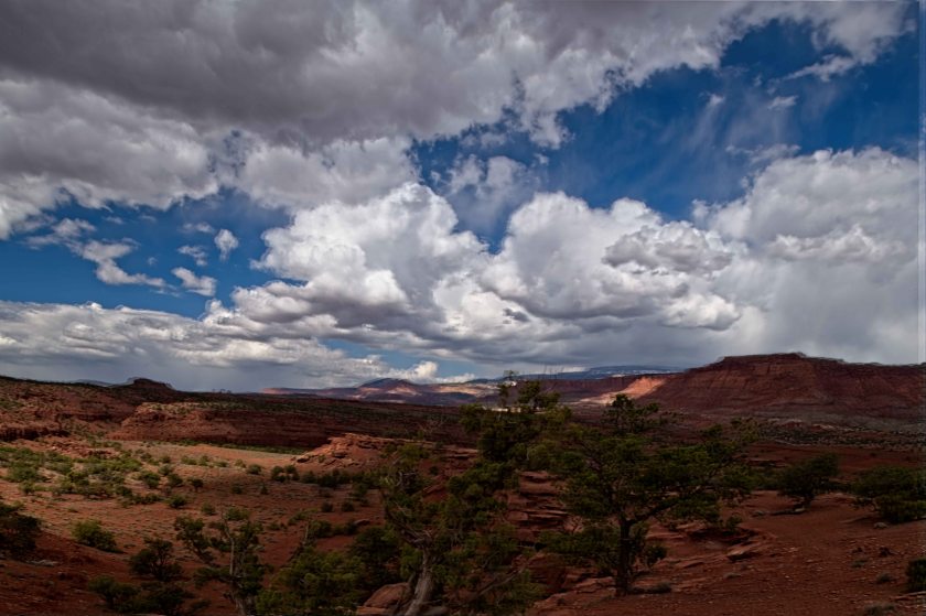
After photographing a bit along our route we stop at the Wayne County Visitor Center to gather information helping to plan our day. It’s a helpful stop and we realize there is way more to do in the area than time we have budgeted. We’re back in the truck heading into Capitol Reef National Park. This National Park has not been on our radar as a place we must see yet the landscapes are incredible. It’s the least visited of the 5 National Parks in Utah. The others are Zion, Bryce, Canyonlands, and Arches. Capitol Reef is a sweet gem. The park’s name comes from a rock formation that resembles the Capitol Building in Washington and from a reeflike formation that is a hundred miles long. It’s also called a water fold.Capital Reef National Park 1

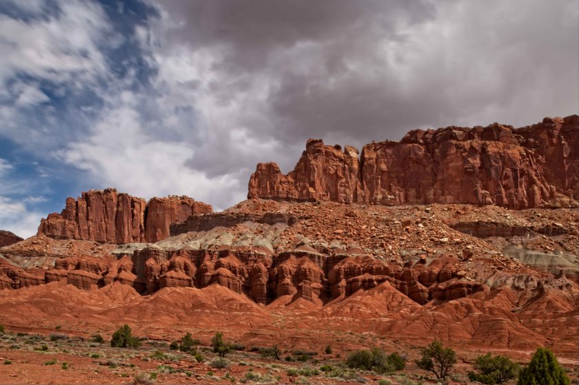
The park campground is full so we stop at the visitor center for more information on the park and if there is a place we can leave our camper for part of the day. The amphitheater parking is our spot. Leaving the trailer we head south on the Park’s 20 mile Scenic Drive that ends in a wash with high cliffs on either side. We take a hike in the wash and see where pioneers wrote their names and dates on the canyon walls. Many of the names were written in 1888 and a group of names on the canyon wall which could only done hanging from a rope from the cliff top. Those were from 1911.

After finishing our hike and completing the scenic drive we pick up our trailer and continue east out of the park. Our next stop is a beat-up purple store that says Café and Cheese on the outside. It’s open but normally we would not stop at what appears to be a dive. The man back at the Wayne County Visitor Center told us about this place. It’s a fifty acre organic farm and Randy, the owner, makes outstanding goat cheeses. We stop and check the place out. Randy is there along with a woman who is running the store. We are asking about the goat cheeses and Randy does not engage in conversation. Rather he difers to the woman. We then ask her about the feelings and thoughts on the US President’s executive orders to reduce Bears Ears National Monument and Grand Staircase Escalante National Monument by huge amounts Randy engages in the discussion. Bears Ears is sacred grounds for the five Native American Tribes in the area. Both places have rock formations that sometimes indicate oil and uranium deposits so the reduction of protected land is an attempt to create wealth for a few people and corporations and destroy the fragile ecosystems. We learn lots.

We head back to the truck as a Ranger comes in and chats with Randy. Next the Ranger approaches us and asks us about our camper. He’s looking to purchase a small Airstream and has many questions so we ask if he wants a tour of our camper. He accepts and we have a great conversation. He grew up on the East Coast but moved out west for college. He loves the West and does what he can to protect the lands. He’s a Ranger for the Bureau of Land Management. We ask about recommendations for dispersed camping for tonight and he recommends a place called Turkey Knob about 35 miles ahead.

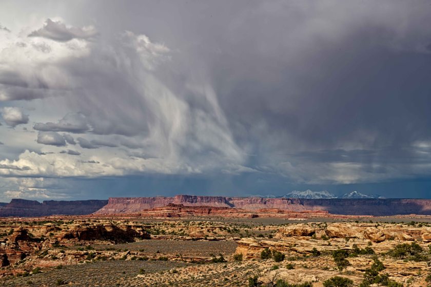
We find Turkey Knob and are camped about half a mile off the highway and it is beautiful. Take a look at some of the photos posted below.

Saturday April 20

We decide to get up early leaving the camper at the campground and do the one hour drive to see the condors. What we didn’t account is the time different between Arizona and Utah. Arizona does not do daylight savings time. The couple from yesterday said the condors start to fly around 9:30 AM. Well, that’s 9:30 Arizona Time while Kanab’s time is 10:30. We need to be back at the campground, hitch up the camper, and checkout by 11 AM. We arrive at 8 AM Kanab time yet that’s 7 AM for the condors. There are no birds to be seen nor do we see anybody else. After an hour of looking and waiting we are rewarded in seeing roughly 10 condors on the ledges high up on the cliffs. They are breathtaking. In 1982 only 22 California Condors remained in the World. All were captures and a captive breeding program was started. Ones raised in captivity are released either in California or where we are now. There are between 400 and 500 condors alive today. The most exciting part of this story is condors are now beginning to successful breed and raise young in the wild.

We return to Kanab, checkout, get supplies and are on the road again. Our route takes us by Bryce Canyon National Park which we decide to bypass. We were there two years ago at this time of year plus today is National Parks Day were all the National Parks are free today. We take Utah 12 through some amazing landscapes and are now camped in Grand Staircase Escalante National Monument.

Friday April 19 – Wire Pass

Wells heads to the Ranger Station in Kanab to enter into the lottery to gain access to The Wave. Never heard of The Wave? It’s several rock formations that look likes huge ocean waves. There are 20 passes issued for each day and each pass represents 1 person. Thus 20 people per day are allowed to take the 6 mile one way hike into The Wave. It’s a photographer’s mecca. 10 of the lottery passes are issued from an online lottery done 3 months in the past and 10 are drawn for the next day. Typically, around 2,000 applications each day are in the online drawing. One application can list up to six people. If an application with 6 people wins then 6 slots are awarded with 4 remaining. The next application drawn can take 1 to 4 of the remaining slots. The process continues until all 10 slots are awarded. So the 2,000 applications may be for 5,000 to 10,000 people. Wells has entered the online lottery several times but the odds of winning are low. Since we are in Kanab we enter the lottery for the next day. Wells finds that there are 86 applications representing more than 250 people for the day. First application drawn is for 5 people and there goes half of the slots. Needless to say we did not win slots.

We decide to hike to Wire Pass which is not too far from White Pocket. The drive to the trailhead is an easy drive of 40 miles on pavement then only 15 miles on decent gravel road. Thinking the hike is up since it’s to a “Pass” Wells brings hiking sticks. They are not needed since the hike is more or less flat. It’s sunny and warm bordering on hot with no shade. The hike is down a wash through deep sand which is a dried streambed without the water. When there is rain in the area one should not do this hike. Flash floods happen quickly.

There is no climbing on the hike just soft sand. In 1 ½ miles the wash becomes a slot canyon. We are enjoying the beauty of these canyons. On the hike we meet a couple and they tell us about seeing condors in the morning where they roost. Maybe we’ll head there tomorrow before we leave the Kanab area.

Thursday April 18 – St. George

After breakfast we head west to St. George. From Kanab to head west one must head east, south, then west following the sparse road selection. We are off to visit with cousins Edie, my Dad’s first cousin, and Pam, her daughter (Wells’ second cousin} and Pam’s husband, Mike. We enjoy several hours with them then begin the two hour drive back to our campsite. On the way home we stop for an oil change which is accomplished in short order.


Wednesday April 17 – Kanab, Utah

We’re off in the morning and drive roughly 80 miles west to Kanob, Utah where we location a campground and set up. Next, we are in the town information center asking about activities in the area. Specifically we gather information on Peekaboo Canyon about 9 miles outside of Kanob. It’s about a 4 mile drive on a one lane sand road. We get to the road and head to the canyon. The sand road is a bit hairy and thoughts of getting stuck it the sand surface in both our minds but we are not vocalizing it to the other.

We do make it to the canyon but the more difficult journey is on the way back since it’s more uphill. Soft, deep sand road going uphill does not bode well. Anyway, we are in the canyon for a couple of hours and there are a few others there as well. A guide with a photographer, another guide with a family from Germany along with a few others.

While shoot Wells chats with the guide that is leading the German Family and he gives Wells to advice in getting out on the road for later. As we exit the Canyon and ready to head out we see the same guide once more and he offers for us to follow him out. We gladly accept his kind offer. It’s a bouncy ride out since in many of the soft areas the way to get through is to drive fairly fast. We make it out with no issues and again thank the guide. Back to Kanab for supper. Tomorrow we are heading to St. George, Utah to visit relatives.