Monday September 2

Monday September 2

Around 4 AM the rain begins and does not bid well for a day outside hiking. We pack up the camper head to town and drive the 20 miles to the National Monument where we park the camper and decide what’s next. Photographing in the rain often works provided the wind is not blowing. Wind tends to blow the rain onto the lens thus making photographing problematic.

It’s windy so it’s not a day for photography.  The National Monument has The Katahdin Loop Road, an 18 mile loop that is mostly one way. The road coming into the Monument as well as the Loop Road are rough gravel. The Park to the camping area is okay for a small trailer but one needs to drive slowly. We are often driving less than 10 mph just to be safe. Leaving the camper we start off on the Loop Road. The speed limit is 15 mph and often that is too fast. It’s a narrow one lane gravel road. Heading off on the loop the wind picks up and everything is blowing around. Not a day for photograph. Along the loop we stop at various places looking at ponds or “views of Mt. Katahdin.” Views of Mt. Katahdin are a pipe dream since we looking at a solid wall of clouds and no mountains are to be seen anywhere.

After completing the drive we head back to the camper and hunker down for the rest of the day into night. Our scouting trip today gives us better ideas what to do tomorrow.

Sunday September 1

Our campsite is close to the road and we are awaken by traffic around 6:30 in the morning. It’s certainly not commuter traffic since we are on the road to Baxter State Park. There is nothing else to create a rush hour. Besides it’s Sunday. Are the cars heading to the Park to make the hike up Mt. Katahdin? Oh well, the traffic subsides and we drift back to sleep.

A bit later in the morning we are up enjoying our coffee and breakfast. It’s time to explore the Park. The narrow road leading to the Park changes to gravel and become very narrow. The Park has no paved roads and is primitive. Arriving at the Park we discover they limit the number of cars allowed into the Park each day. On Sunday of Labor Day there are plenty who are enjoying the Park. You state where you are heading and they tell you if there is availability there or not. Those cars going by at 6:30 were heading to enter the Park at opening time of 7 AM. We hiked in the Park back in 1982 and there were no controls such as now.

We find that there is space for a hike to Little Niagara and Big Niagara Falls about ten miles into the Park so we reserve a parking spot for that. The speed limit along the Tote Road is 20 mph except lower near other parking areas. The hike to the falls is along the Appalachian Trail close to the northern end. A day hike north along the trail puts one on top of Mt. Katahdin, but we are hiking south along the trail. Shortly into our hike we meet a 71 year old man that over the past couple of years has been hiking the AT. Tomorrow he’ll complete his journey. His brother had convinced him to hike the entire AT and he agreed so his brother didn’t have to do the hike alone. Well, after a few hundred miles his brother decided to stop but he was hooked and kept going.

Wells is not expecting to capture great waterfall photos since it’s a sunny day with only a few clouds, but he carries his camera backpack anyway.  Arriving at the falls we wonder about how they got there names of Little and Big Niagara. Wells grabs a couple of shots and we head back towards the truck.

Marsha has been hoping to see Boreal Chickadees on this trip but they’ve been as elusive as moose. Up in the tree tops Wells hears Boreal Chickadees but Marsha has yet to lay eyes on one. We finish the hike and decide to head into town 9 miles beyond our campground. We are after a few supplies plus hoping to visit a photo gallery she read about.

Turns out the Gallery is open everyday except Wednesdays and Sundays but we luck out and it’s open. It’s a photo gallery that the woman at the gallery, Anita, and her husband own, run, and do all the photography. The primary subject matter for the gallery is Moose. www.mooseprintsgallery.com

We chat with Anita at length and she tells us about a National Monument, Katahdin Lands and Waters created in August of 2016. It’s roughly 90,000 acres and has a free primitive camping area. Here’s our destination for the next few days!

Saturday August 31 – Happy Birthday Marni!

Happy Birthday Marni! Our daughter turns 27 today. We are proud of her accomplishments and where she is with her life now. After we call and “sing” happy birthday to her we have a long chat. We head into Moncton for the Saturday Farmer’s Market. There we secure a few goodies for the road, head back to get the trailer and head out. It’s Saturday of the holiday weekend and we have no clue where we will be tonight. We expect most campgrounds will be full so we may end up boon docking someplace. We decide it’s time head towards Baxter State Park in Northern Maine. We are not sure how to leave New Brunswick since we don’t yet have a map of Maine. We head west along the Trans Canada until we reach the intersection with Interstate 95 into Maine. We cross the border and are back in the States for the first time since July 12th. Once in Maine we get a map and tourist information. We make couple of calls and mange to locate a campground that has room for us located near the southern entrance to Baxter State Park. After stocking up on supplies we had to the campground where we arrive in time for a rousing game of Cribbage. We enjoy a delightful meal of fresh corn, turkey tenderloin, and great salad.

We are here for two nights then decide where to head next.

Friday August 30

Surfing the Tidal Bore 1Surfing the Tidal Bore
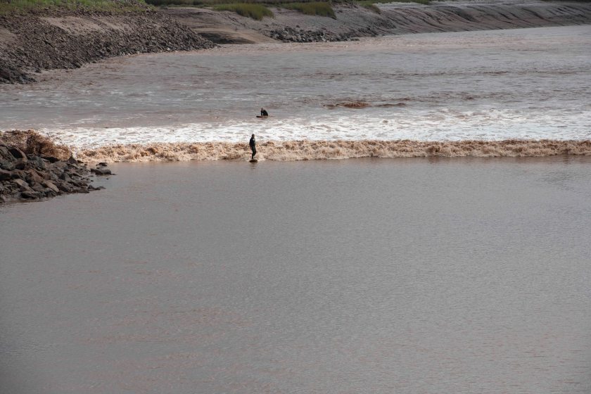
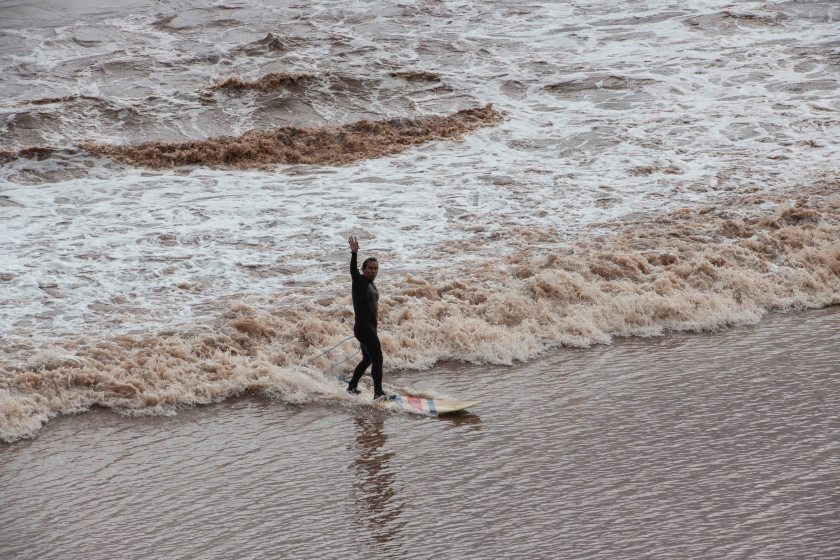
Our visit to Moncton is to see the tidal bore. The Bay of Fundy has the highest tides in the entire world. They often exceed 30 feet. When the tide starts to rise one cannot out run the incoming tide so one must be aware of the tide times and when it starts to come in. This is only important if you are out exploring the exposed tidal flats.

Along the riverfront in Moncton the tidal bore surges up river as a wave of water. The city has a small park for viewing this phenomenon, aptly named Bore Park. Tides occur twice a day with the cycle from low tide to high tide of roughly 6 ½ hours. Thus if high tide is at noon today there’s another high tide around 12:30 AM tomorrow and another around 1 PM tomorrow. There are approximately sixty factors at determine tidal frequency and magnitude with the largest factor being the moon.

The tidal bore prediction for today is at 10:11 AM and it can vary by up to 20 minutes before or after. We check in at the office and they are still not sure if they will have a space for us tonight but checkout is not until 1 PM so we decide to head to the riverfront see the bore and return to the campground. There we can either move the camper or check out.

We head to Tidal Bore Park arriving a bit past 9:30. There’s a view area overlooking the river. What we witness is exposed mud banks with chocolate water the same color as the mud. The crowd grows until the railing has people shoulder to shoulder ready watch. On the river there are two surfers paddling down river towards where the bore will come. They disappear around the riverbend now more than a mile from us.

The time is 10:11 and soon someone yells out here it comes. It’s a wave of chocolate water maybe three feet high with the two surfers riding the wave. One of the surfers wipes out. It’s a bummer for the surfer because the next wave will not come along until roughly 11 PM tonight. The other one hangs on. As he surfs past the viewing area he has a big wave and flashes a huge smile for the crowd.

We walk around downtown Moncton for a bit then head back to the campground. They have a new spot for us so we move the trailer and set up camp again. We contact our Facebook Friend, Sybil, the photographer who has been feeding us valuable information on sandpipers and tidal bores. We plan to meet with Sybil and Peter for coffee at 2 PM about 45 minutes down the coast from Moncton. This is the same photographer that Wells has admired for five years and has never met.

They suggest Cinnamon Soul Café. We arrive a bit early and realize we’ve eaten here before on our return from Newfoundland two years ago. Sybil and Peter arrive and we are at total ease with them. Our planned meeting of maybe a cup of coffee morphs into a three hour enjoyable and interesting meeting. Hopefully our paths will cross in the future.

Thursday August 29

Remnants of a tropical storm move in this morning with rain. The forecast is for rain over the next 18 hours so we decide to push south. Wishing to witness The Bay of Fundy’s tidal bore we reach out to the woman that gave us the scoop on the sandpipers there. She says the best place to see the tidal bore is in downtown Moncton along the river front. We set our sights for Moncton.

The Park RV dump station is out to pavement plus another ten miles up the road. The water at this campground is not potable but is obtainable it near the dump station. It’s along our path to Moncton so we dump and load up with fresh water. On to Moncton or rather On to Moncton in the rain.

As the reader can determine we are not micro planners. We plan for the big picture. For example, this trip only had general plans. We wish to travel the Trans Labrador Highway; Explore Newfoundland; See Puffins and Northern Gannets; and Explore other areas of Atlantic Canada. There are few premediated specific plans and we go where the flow brings us. In our travels we encounter the spectrum of travelers from ones with no specific plans to ones that plan out where they are and what they will do each day. The disadvantage of our travel style is we don’t know where we are staying each night. What campground has vacancy? Normally this is not a problem except in two situations. First, in the highly touristed areas finding a campground can be difficult and second on holiday weekends when everybody is camping. The weekend is a holiday weekend so we are a bit uneasy on where we can find accommodations. We locate a campground just outside of Moncton that has room for us for one night and we take it. They tell us they might have another space for tomorrow night but will not know until the morning. We’ll find out then.

Wednesday August 28

Gaspesie National Park has an Adirondack feel to it with forests and round topped mountains. We first scout an accessible waterfall. The hike is easy but Wells leaves the camera gear in the truck. With the bright sun it’s not the right light for photographing waterfalls. The viewpoint for the falls is disappointing where water plunges down into a narrow cataract yet only the top portion of the falls is visible. The scouting trip determines that even in great light this is not a waterfall to photograph. There is no way to reach a better vantage point. We retrace our steps back to the truck and head to our next hike.

This park does not appear to be bilingual. There are park programs every day but only in French. In the parking lot over 95 percent of the cars have Quebec plates and seldom do we hear English spoken.

We head out for a peak that has a 360 degree view. The trail is not steep yet uphill the whole way. Wells is loaded down with equipment. On the trail the common greeting of bonjour is uttered by all. We encounter a couple with a baby less than a year old and we attempt to connect with no luck. At the top we see them again and their baby successful connects with us and we with him. The three of them are from Paris and are on a holiday to Eastern Canada.

Once back to the truck we are tired and head back to the campground. The campground is located 8 miles off the beaten track at the end of a gravel road. The road climbs over 1,500 feet then drops a bit into the campground on the lake.

Tuesday August 27

We pack up and leave for Gaspesie National Park. This includes the highlands of the Gaspe area with a dozen peaks over 3000 feet. We resupply food in Gaspe village then head towards the northern coast of the peninsular which makes up the southern shore of the Gulf of St. Lawrence. The drive along the northern shore is jaw dropping with dramatic cliffs plunging to the shore as the road snakes along the shore at sea level.

It’s late in the day when we reach our campsite. We break out the grill and enjoy grilled veggies with a pasta dish. We enjoy a couple of beers made by Pit Caribou a Gaspe Peninsular micro brewery, play cribbage, and hit the hay.

Monday August 27

Today we hike the 3 miles one way to Lands End. There are two routes to chose from, the hiking trail and the “access road.” The trail has an extra 300 feet of elevation gain with lots of small ups and downs. Both ways offer incredible views south. Off in the distance Bonaventure Island is visible. As we watch Northern Gannets diving for food we guess they are from the gannet colony on the Island. It’s a long hike with the camera gear but you never know when the right photographic opportunity will surface.

At Lands End there’s a lighthouse and cliffs that jut into the ocean. This is the northern end of the Appalachian Mountain chain.


Once back to the truck we explore various areas of the National Park then head back to camp for supper, cards, and bed.

Sunday August 25

We pack up out camp and head to Forillion National Park about 50 miles up the road. This National Park is the eastern park of the Gaspe Peninsular including “Lands End,” the eastern most point of  Quebec. Here begins the Gulf of St. Lawrence. We settle into one of the National Park campgrounds and decide to hike to La Chute Waterfall. It’s a sunny day so Wells does not have high expectations of getting a decent photograph of the falls since it’s too bright. Despite the sun he packs camera, three lenses, and tripod. The falls faces north and is complete shadow so the photo gods are with him today and he captures good images. On this hike one is reminded that to visit the base of a waterfall involves ups and downs.


We scout for where to hike tomorrow and decide on Lands End. Marsha spots a whale but Wells misses it. It reminds us of Wrangle St. Elias National Park in Alaska when Wells saw a wolf and Marsha didn’t.


Saturday August 24

We are up and ready to walk into town and catch the 9 AM boat to the Island. The boat first travels out to Perce Rock then fully circles Bonaventure Island before dropping us off at the Park Entrance. On the boat ride which is a bit rough we travel close to Perce Rock then get views of the nesting Northern Gannets along the cliffs of the Island. Once dropped off on the Island we undergo an orientation briefing then head out on the two and a half km hike to the colony.

Northern Gannets are weird birds in many ways. Over the ocean they are amazing fliers and successful hunters of fish with arrowlike dives into the water from 100 yards above. On land they are somewhat awkward and even more awkward in their attempts to land on the ground. During the nesting season the only thing they focus on is their nest site and fishing. It is as if nothing else in the world exists for them. Each nest site consists of mostly bare ground with a bit of dried grass and is approximately a square foot in size. If an intruder ventures into their nest site they fiercely fight off the intruder be it another Northern Gannet or even their own chick if somehow the chick had gotten out of the nest site and is now returning. If a neighbor is beyond the one square foot then they are fine. They do not care about anything outside their one square foot. Thus, to view the nesting colony there is a rope fence that people can go up to but not beyond. Five feet away is the nesting colony. The birds are jaw dropping in how close you can get and they totally ignore you.

We stay with the colony for four hours observing and photographing then start the 45 minute hike back to the boat. Wells is weighed down with many pounds of camera equipment but it is so worth it. Once back in Perce we grab a late lunch then head back to our camper. Tonight’s dinner, a delightful salad.